|
|
Antenna Structure Registration 1049262 |
 |
Registration Info | Registration Number: 1049262 |
| File Number: A1146918 |
| FAA Study: 2018-ANE-4325-OE |
| FAA Issue Date: 08/15/2018 |
| Status: Constructed |
| Date Constructed: 05/28/1998 |
| NEPA: N |
Structure Info
| Structure Type: LTOWER |
| Structure Coordinates: 41-59-49.4 N 71-9-14.3 W (NAD 83) |
| Structure Coordinates: 41-59-49.0 N 71-09-16.1 W (Converted to NAD 27) |
| Structure Address: 308 E. Main Street |
| Structure City: Norton, MA |
| Structure County: Bristol County |
| Painting & Lighting Info |
FAA Chapters: NONE |
Remarks: PRIOR STUDY 2000-ANE-103-OE |
Remarks: Removed expiration date from determination. Scenario 1./jjs/case#635066 |
Remarks: PRIOR STUDY 2000-ANE-103-OE |
Remarks: Removed expiration date from determination. Scenario 1./jjs/case#635066 |
| Elevation Info |
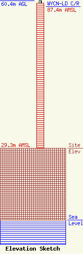
Site Elevation: 29.3 meters (96 ft) |
| Height of Structure: 59.4 meters (195 feet) |
| Overall Height Above Ground: 60.4 meters (198 feet) |
| Overall Height Above Mean Sea Level: 89.7 meters (294 feet) |
| WYCN-LD C/R Height Above Mean Sea Level: 87.4 meters (287 ft)
|
| Owner Info | CCATT LLC
2000 Corporate Drive
Canonsburg, PA 15317
(724) 416-2000
Regulatory.Department@Crowncastle.com |
| Contact Info | Crown Castle
2000 Corporate Drive
Canonsburg, PA 15317
Don Snyder
(724) 416-2470
Don.Snyder@crowncastle.com |
