|
|
Antenna Structure Registration 1049345 |
 |
Registration Info | Registration Number: 1049345 |
| File Number: A1131294 |
| FAA Study: 2017-ASW-15714-OE |
| FAA Issue Date: 10/31/2017 |
| Status: Constructed |
| Date Constructed: 02/09/1996 |
| NEPA: N |
Structure Info
| Structure Type: GTOWER |
| Structure Coordinates: 32-4-5.0 N 102-13-52.9 W (NAD 83) |
| Structure Coordinates: 32-04-04.6 N 102-13-51.4 W (Converted to NAD 27) |
| Structure Address: 8308 Craddick Hwy (tx20991-a) |
| Structure City: Midland, TX |
| Structure County: Midland County |
| Painting & Lighting Info |
FAA Circular #: 70/7460-1L |
FAA Chapters: 3, 4, 5, 12 |
Remarks: PRIOR STUDY 1995-ASW-135-OE |
Remarks: Removed expiration date from determination. Scenario 1./jjs/case#635066 |
Remarks: PRIOR STUDY 1995-ASW-135-OE |
Remarks: Removed expiration date from determination. Scenario 1./jjs/case#635066 |
| Elevation Info |
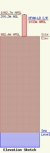
Site Elevation: 882.4 meters (2895 ft) |
| Height of Structure: 196.3 meters (644 feet) |
| Overall Height Above Ground: 200.3 meters (657 feet) |
| Overall Height Above Mean Sea Level: 1082.7 meters (3552 feet) |
| KFAW-LD C/R Height Above Mean Sea Level: 1033 meters (3389 ft)
|
| Owner Info | SBA Steel, LLC.
8051 Congress Avenue
Boca Raton, FL 33487
(561) 995-7670
ERoach@sbasite.com |
| Contact Info | SBA Steel, LLC.
8051 Congress Avenue
Boca Raton, FL 33487
(561) 995-7670
ERoach@sbasite.com |
