|
|
Antenna Structure Registration 1049508 |
 |
Registration Info | Registration Number: 1049508 |
| File Number: A0984821 |
| FAA Study: 2015-AEA-6908-OE |
| FAA Issue Date: 12/10/2015 |
| Status: Constructed |
| Date Constructed: 11/07/2008 |
| NEPA: N |
Structure Info
| Structure Type: LTOWER |
| Structure Coordinates: 38-53-45.0 N 77-8-6.8 W (NAD 83) |
| Structure Coordinates: 38-53-44.6 N 77-08-07.9 W (Converted to NAD 27) |
| Structure Address: 5301 22nd Street (088278 / Arlington Garden City Va) |
| Structure City: Arlington, VA |
| Structure County: Arlington County |
| Painting & Lighting Info |
FAA Circular #: 70/7460-1L |
FAA Chapters: 4, 8, 12 |
Remarks: OM&L to remain the same as prior study = A MED-DUAL SYSTEM |
Remarks: PRIOR STUDY 2013-AEA-6883-OE |
Remarks: OM&L to remain the same as prior study = A MED-DUAL SYSTEM |
Remarks: PRIOR STUDY 2013-AEA-6883-OE |
| Elevation Info |
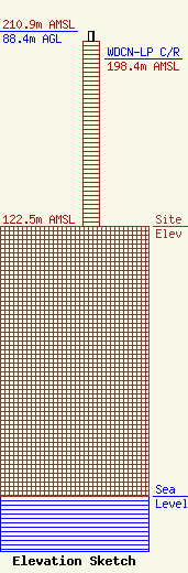
Site Elevation: 122.5 meters (402 ft) |
| Height of Structure: 83.8 meters (275 feet) |
| Overall Height Above Ground: 88.4 meters (290 feet) |
| Overall Height Above Mean Sea Level: 210.9 meters (692 feet) |
| WDCN-LP C/R Height Above Mean Sea Level: 198.4 meters (651 ft)
|
| Owner Info | American Towers LLC
10 Presidential Way
Woburn, MA 01801
(678) 564-3236
faa-fcc@americantower.com |
| Contact Info | American Towers, LLC.
10 Presidential Way
Woburn, MA 01801
(678) 564-3236
faa-fcc@americantower.com |
