|
|
Antenna Structure Registration 1049715 |
 |
Registration Info | Registration Number: 1049715 |
| File Number: A1214951 |
| FAA Study: 2013-ASW-2965-OE |
| FAA Issue Date: 07/26/2018 |
| Status: Constructed |
| Date Constructed: 05/27/2014 |
| FAA EMI: N |
| NEPA: N |
Structure Info
| Structure Type: GTOWER |
| Structure Coordinates: 32-23-45.2 N 101-57-21.3 W (NAD 83) |
| Structure Coordinates: 32-23-44.8 N 101-57-19.8 W (Converted to NAD 27) |
| Structure Address: Along Route 829 11km North Of Rt. 176 |
| Structure City: Patricia, TX |
| Structure County: Martin County |
| Painting & Lighting Info |
FCC Paragraph(s): 1, 3, 6, 15, 21 |
Remarks: Continue As Is OM&L = PAINT/RED LIGHTS |
Remarks: PRIOR STUDY 1987-ASW-1616-OE |
Remarks: Continue As Is OM&L = PAINT/RED LIGHTS |
Remarks: PRIOR STUDY 1987-ASW-1616-OE |
| Elevation Info |
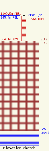
Site Elevation: 864.1 meters (2835 ft) |
| Height of Structure: 244.4 meters (802 feet) |
| Overall Height Above Ground: 245.4 meters (805 feet) |
| Overall Height Above Mean Sea Level: 1109.5 meters (3640 feet) |
| KTXC C/R Height Above Mean Sea Level: 1096 meters (3596 ft)
|
| Owner Info | VCY America, Inc.
3434 West Kilbourn Avenue
Milwaukee, WI 53208
(414) 935-3000
jims@vcyamerica.org |
| Contact Info | Wiley Rein LLP
2050 M Street, N.W.
Washington, DC 20036
Kathryne Dickerson
(202) 719-7279
kdickerson@wiley.law |
