|
|
Antenna Structure Registration 1053390 |
 |
Registration Info | Registration Number: 1053390 |
| File Number: A1262078 |
| FAA Study: 2019-ASW-17086-OE |
| FAA Issue Date: 12/06/2019 |
| Status: Constructed |
| Date Constructed: 10/01/1991 |
| NEPA: N |
Structure Info
| Structure Type: GTOWER |
| Structure Coordinates: 30-58-32.2 N 93-59-25.4 W (NAD 83) |
| Structure Coordinates: 30-58-31.5 N 93-59-24.7 W (Converted to NAD 27) |
| Structure Address: 3.8 Miles North Of Jasper, Tx On West Side Of Hwy 96 |
| Structure City: Jasper, TX |
| Structure County: Jasper County |
| Painting & Lighting Info |
FAA Circular #: 70/7460-1L |
FAA Chapters: 4, 8, 12 |
Remarks: PRIOR STUDY 1991-ASW-1197-OE |
| Elevation Info |
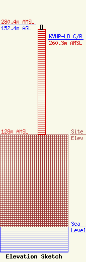
Site Elevation: 128 meters (420 ft) |
| Height of Structure: 146.3 meters (480 feet) |
| Overall Height Above Ground: 152.4 meters (500 feet) |
| Overall Height Above Mean Sea Level: 280.4 meters (920 feet) |
| KVHP-LD C/R Height Above Mean Sea Level: 260.3 meters (854 ft)
|
| Owner Info | EIP Holdings II, LLC
Two Allegheny Center, Nova Tower 2
PITTSBURGH, PA 15212
(844) 282-7748
regulatory@everestinfrastructure.com |
| Contact Info | EIP Holdings II, LLC
Two Allegheny Center, Nova Tower 2
Pittsburgh, PA 15212
Justin Burgess
(844) 282-7748
regulatory@everestinfrastructure.com |
