|
|
Antenna Structure Registration 1053994 |
 |
Registration Info | Registration Number: 1053994 |
| File Number: A0579153 |
| FAA Study: 2007-ASW-7814-OE |
| FAA Issue Date: 12/24/2007 |
| Status: Granted |
| Date Constructed: 10/01/1985 |
| NEPA: N |
Structure Info
| Structure Type: TOWER |
| Structure Coordinates: 32-35-25.0 N 96-58-24.0 W (NAD 83) |
| Structure Coordinates: 32-35-24.5 N 96-58-23.0 W (Converted to NAD 27) |
| Structure Address: 1450 W Beltline Rd |
| Structure City: Cedar Hill, TX |
| Structure County: Dallas County |
| Painting & Lighting Info |
FAA Circular #: 70/7460-1K |
FAA Chapters: 4, 5, 12 |
Remarks: PRIOR STUDY 1998-ASW-2155-OE |
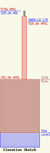
| Elevation Info |
Site Elevation: 252.8 meters (829 ft) |
| Height of Structure: 299.8 meters (984 feet) |
| Overall Height Above Ground: 325.2 meters (1067 feet) |
| Overall Height Above Mean Sea Level: 578 meters (1896 feet) |
| KWDA-LD C/R Height Above Mean Sea Level: 526.8 meters (1728 ft)
|
| Owner Info | Sonsinger Broadcasting Company of Houston, L.P.
855 Aviation Drive, Suite 200
Camarillo, CA 93010
(805) 389-9302
bcounsil@sunairjets.com |
| Contact Info | Sonsinger Broadcasting Company of Houston, L.P.
855 Aviation Drive, Suite 200
Camarillo, CA 93010
Brian Counsil
(805) 389-9302
bcounsil@sunairjets.com |
