|
|
Antenna Structure Registration 1054130 |
 |
Registration Info | Registration Number: 1054130 |
| File Number: A0063645 |
| FAA Study: 90-ASW-0147-OE |
| FAA Issue Date: 03/01/1990 |
| Status: Constructed |
| Date Constructed: 01/01/1998 |
| NEPA: N |
Structure Info
| Structure Type: BANT |
| Structure Coordinates: 27-48-0.0 N 97-23-31.0 W (NAD 83) |
| Structure Coordinates: 27-47-58.9 N 97-23-30.0 W (Converted to NAD 27) |
| Structure Address: 800 North Shoreline Drive |
| Structure City: Corpus Christi, TX |
| Structure County: Nueces County |
| Painting & Lighting Info |
FAA Circular #: 70/7460-1G |
FAA Chapters: 3, 4, 5, 9 |
| Elevation Info |
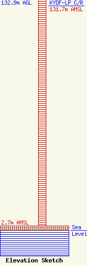
Site Elevation: 2.7 meters (9 ft) |
| Height of Structure: 132.9 meters (436 feet) |
| Overall Height Above Ground: 132.9 meters (436 feet) |
| Overall Height Above Mean Sea Level: 135.6 meters (445 feet) |
| KYDF-LP C/R Height Above Mean Sea Level: 131.7 meters (432 ft)
|
| Owner Info | SHORELINE VENTURE LIMITED DBA = ONE SHORELINE PLAZA
510 BERING, SUITE 500
HOUSTON, TX 77057
(713) 570-3052
SPECTRUM@CROWNCASTLE.COM |
