|
|
Antenna Structure Registration 1054581 |
 |
Registration Info | Registration Number: 1054581 |
| File Number: A0653721 |
| FAA Study: 2002-ASO-4114-OE |
| FAA Issue Date: 08/19/2002 |
| Status: Constructed |
| Date Constructed: 08/29/2002 |
| FAA EMI: N |
| NEPA: N |
Structure Info
| Structure Type: BPOLE |
| Structure Coordinates: 30-19-33.8 N 81-39-32.2 W (NAD 83) |
| Structure Coordinates: 30-19-32.9 N 81-39-32.9 W (Converted to NAD 27) |
| Structure Address: One Independent Drive |
| Structure City: Jacksonville, FL |
| Structure County: Duval County |
| Painting & Lighting Info |
FCC Paragraph(s): 2 |
Remarks: OM&L TO REMAIN RED LIGHTS AS PER PRIOR STUDY 1983-ASO-1496-OE |
| Elevation Info |
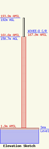
Site Elevation: 1.9 meters (6 ft) |
| Height of Structure: 158.7 meters (521 feet) |
| Overall Height Above Ground: 192 meters (630 feet) |
| Overall Height Above Mean Sea Level: 193.9 meters (636 feet) |
| W30EE-D C/R Height Above Mean Sea Level: 167.9 meters (551 ft)
|
| Owner Info | ONE INDEPENDENT SQUARE, LLC
ONE INDEPENDENT DRIVE SUITE 1850
JACKSONVILLE, FL 32202
(904) 356-1978
|
| Contact Info | EOLA CAPITAL
ONE INDEPENDENT DRIVE SUITE 1850
JACKSONVILLE, FL 32202
DAN FREY
(904) 356-1978
dfrey@eolacapital.com |
