|
|
Antenna Structure Registration 1055026 |
 |
Registration Info | Registration Number: 1055026 |
| File Number: A0064715 |
| FAA Study: 98-AGL-1029-OE |
| Status: Constructed |
| Date Constructed: 08/10/1998 |
| NEPA: N |
Structure Info
| Structure Type: TOWER |
| Structure Coordinates: 44-48-17.0 N 95-34-50.0 W (NAD 83) |
| Structure Coordinates: 44-48-17.2 N 95-34-48.9 W (Converted to NAD 27) |
| Structure Address: 2.4 Km Wsw On St Hwy 67 |
| Structure City: Granite Falls, MN |
| Structure County: Yellow Medicine County |
| Painting & Lighting Info |
FAA Circular #: 70/7460-1J |
FAA Chapters: 4, 6, 13 |
| Elevation Info |
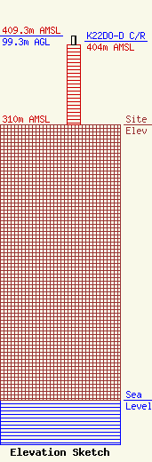
Site Elevation: 310 meters (1017 ft) |
| Height of Structure: 89.9 meters (295 feet) |
| Overall Height Above Ground: 99.3 meters (326 feet) |
| Overall Height Above Mean Sea Level: 409.3 meters (1343 feet) |
| K22DO-D C/R Height Above Mean Sea Level: 404 meters (1325 ft)
|
| Owner Info | MINNESOTA VALLEY TV IMPROVEMENT CORPORATION
750 PRENTICE ST
A
GRANITE FALLS, MN 56241
(320) 564-4970
|
