|
|
Antenna Structure Registration 1058877 |
 |
Registration Info | Registration Number: 1058877 |
| File Number: A0618686 |
| FAA Study: 2007-AEA-6172-OE |
| FAA Issue Date: 12/12/2007 |
| Status: Constructed |
| Date Constructed: 01/28/2008 |
| FAA EMI: N |
| NEPA: N |
Structure Info
| Structure Type: TOWER |
| Structure Coordinates: 37-47-6.4 N 81-6-47.4 W (NAD 83) |
| Structure Coordinates: 37-47-06.0 N 81-06-48.0 W (Converted to NAD 27) |
| Structure Address: 124 Industrial Park Road |
| Structure City: Beaver, WV |
| Structure County: Raleigh County |
| Painting & Lighting Info |
FAA Chapters: NONE |
Remarks: PRIOR STUDY 2002-AEA-2104-OE |
| Elevation Info |
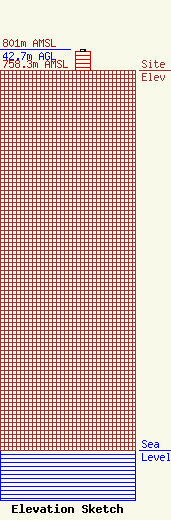
Site Elevation: 758.3 meters (2488 ft) |
| Height of Structure: 39.6 meters (130 feet) |
| Overall Height Above Ground: 42.7 meters (140 feet) |
| Overall Height Above Mean Sea Level: 801 meters (2628 feet) |
| Owner Info | West Virginia Educational Broadcasting Authority
600 Capitol Street
Charleston, WV 25301
(304) 556-4900
dadkins@wvpubcast.org |
| Contact Info | West Virginia Public Broadcasting
9004
Beckley, WV 25802-9004
Calvin Hannah
(304) 254-7867
channah@wvpubcast.org |
