|
|
Antenna Structure Registration 1059838 |
 |
Registration Info | Registration Number: 1059838 |
| File Number: A1286490 |
| FAA Study: 2024-ASO-7314-OE |
| FAA Issue Date: 05/30/2024 |
| Status: Constructed |
| Date Constructed: 06/10/2024 |
| NEPA: N |
Structure Info
| Structure Type: GTOWER |
| Structure Coordinates: 35-55-54.9 N 78-51-50.1 W (NAD 83) |
| Structure Coordinates: 35-55-54.4 N 78-51-51.1 W (Converted to NAD 27) |
| Structure Address: Moore Dr. Ext |
| Structure City: Durham, NC |
| Structure County: Durham County |
| Painting & Lighting Info |
FAA Circular #: 70/7460-1M |
FAA Chapters: 4, 8, 15 |
| Elevation Info |
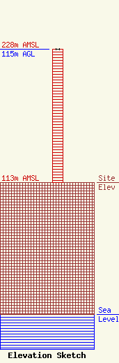
Site Elevation: 113 meters (371 ft) |
| Height of Structure: 115 meters (377 feet) |
| Overall Height Above Ground: 115 meters (377 feet) |
| Overall Height Above Mean Sea Level: 228 meters (748 feet) |
| Owner Info | University of North Carolina
10 UNC-TV Drive
14900
RESEARCH TRIANGLE PK, NC 27709
(919) 549-7000
fcc_notice@pbsnc.org |
| Contact Info | University of North Carolina
10 UNC-TV Drive
14900
Research Triangle Pk, NC 27709
Donald Smith
(919) 549-7025
dsmith@pbsnc.org |
