|
|
Antenna Structure Registration 1061133 |
 |
Registration Info | Registration Number: 1061133 |
| File Number: A0071606 |
| FAA Study: 88-AEA-0194-OE |
| FAA Issue Date: 03/24/1988 |
| Status: Constructed |
| Date Constructed: 11/01/1987 |
| NEPA: N |
Structure Info
| Structure Type: TOWER |
| Structure Coordinates: 43-8-7.0 N 77-35-6.0 W (NAD 83) |
| Structure Coordinates: 43-08-06.8 N 77-35-07.0 W (Converted to NAD 27) |
| Structure Address: 1156 Highland Ave |
| Structure City: Rochester, NY |
| Structure County: Monroe County |
| Painting & Lighting Info |
FAA Chapters: None |
Remarks: Removed expiration date from determination. Scenario 1./jjs/case#635066 |
| Elevation Info |
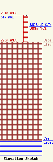
Site Elevation: 220 meters (722 ft) |
| Height of Structure: 61 meters (200 feet) |
| Overall Height Above Ground: 61 meters (200 feet) |
| Overall Height Above Mean Sea Level: 281 meters (922 feet) |
| WNIB-LD C/R Height Above Mean Sea Level: 255 meters (837 ft)
|
| Owner Info | PINNACLE HILL ASSOCIATES INC
992 CARTER ST
ROCHESTER, NY 14621
(716) 342-6822
|
