|
|
Antenna Structure Registration 1062431 |
 |
Registration Info | Registration Number: 1062431 |
| File Number: A0257874 |
| FAA Study: 98-ANM-1005-OE |
| FAA Issue Date: 03/15/1999 |
| Status: Constructed |
| Date Constructed: 10/09/2000 |
| FAA EMI: N |
| NEPA: N |
Structure Info
| Structure Type: TOWER |
| Structure Coordinates: 47-43-33.0 N 117-10-10.0 W (NAD 83) |
| Structure Coordinates: 47-43-33.4 N 117-10-06.3 W (Converted to NAD 27) |
| Structure Address: Antoine Peak |
| Structure City: Millwood, WA |
| Structure County: Spokane County |
| Painting & Lighting Info |
FAA Circular #: 70/7460-1J |
FAA Chapters: 4, 5, 13 |
Remarks: REFER TO PRIOR STUDY 98-ANM-0720-OE |
Remarks: Removed expiration date from determination. Scenario 1./jjs/case#635066 |
| Elevation Info |
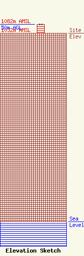
Site Elevation: 1032 meters (3386 ft) |
| Height of Structure: 49 meters (161 feet) |
| Overall Height Above Ground: 50 meters (164 feet) |
| Overall Height Above Mean Sea Level: 1082 meters (3550 feet) |
| Owner Info | QueenB Radio, Inc.
500 West Boone Avenue
Spokane, WA 99201
(509) 324-4000
|
