|
|
Antenna Structure Registration 1063563 |
 |
Registration Info | Registration Number: 1063563 |
| File Number: A1204032 |
| FAA Study: 96-ASO-4536-OE |
| FAA Issue Date: 09/17/1996 |
| Status: Constructed |
| Date Constructed: 08/29/1996 |
| FAA EMI: N |
| NEPA: N |
Structure Info
| Structure Type: TOWER |
| Structure Coordinates: 33-32-33.0 N 86-30-31.0 W (NAD 83) |
| Structure Coordinates: 33-32-32.6 N 86-30-31.1 W (Converted to NAD 27) |
| Structure Address: 100 Horab Dr |
| Structure City: Leeds, AL |
| Structure County: Shelby County |
| Painting & Lighting Info |
FAA Chapters: NONE |
| Elevation Info |
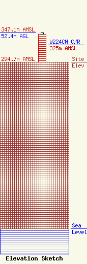
Site Elevation: 294.7 meters (967 ft) |
| Height of Structure: 49.4 meters (162 feet) |
| Overall Height Above Ground: 52.4 meters (172 feet) |
| Overall Height Above Mean Sea Level: 347.1 meters (1139 feet) |
| W224CN C/R Height Above Mean Sea Level: 325 meters (1066 ft)
|
| Owner Info | Dawson Enterprises Investing, LLC
1543 Mill Creek Cir
Salem, AR 72576
(870) 750-8024
dawsonenterprisesinc@gmail.com |
| Contact Info | Dawson Enterprises Investing, LLC
1543 Mill Creek Cir
Salem, AR 72576
Dustin Dawson
(870) 750-8024
dawsonenterprisesinc@gmail.com |
