|
|
Antenna Structure Registration 1063735 |
 |
Registration Info | Registration Number: 1063735 |
| File Number: A0074358 |
| FAA Study: 99-ASW-1026-OE |
| FAA Issue Date: 04/08/1999 |
| Status: Constructed |
| Date Constructed: 09/01/1992 |
| NEPA: N |
Structure Info
| Structure Type: TOWER |
| Structure Coordinates: 34-41-26.0 N 93-56-35.0 W (NAD 83) |
| Structure Coordinates: 34-41-25.6 N 93-56-34.3 W (Converted to NAD 27) |
| Structure Address: Buck Knob Mountain |
| Structure City: Scott County, AR |
| Structure County: Scott County |
| Painting & Lighting Info |
FCC Paragraph(s): 1, 3, 11, 21 |
Remarks: OM&L TO REMAIN PAINT/RED LIGHTS AS PER PRIOR STUDY 92-ASW-0910-OE. |
| Elevation Info |
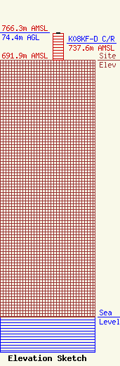
Site Elevation: 691.9 meters (2270 ft) |
| Height of Structure: 73.7 meters (242 feet) |
| Overall Height Above Ground: 74.4 meters (244 feet) |
| Overall Height Above Mean Sea Level: 766.3 meters (2514 feet) |
| K08KF-D C/R Height Above Mean Sea Level: 737.6 meters (2420 ft)
|
| Owner Info | PEARSON BROADCASTING OF MENA, INC.
100 FALL CREEK DRIVE, SUITE # B
BRANSON, MO 65616
(417) 335-2261
MHENDEE@PEARSONBROADCASTING.COM |
