|
|
Antenna Structure Registration 1200269 |
 |
Registration Info | Registration Number: 1200269 |
| File Number: A0616064 |
| FAA Study: BOS-OE-67-166 |
| FAA Issue Date: 05/31/1967 |
| Status: Constructed |
| Date Constructed: 03/26/2007 |
| FAA EMI: N |
| NEPA: N |
Structure Info
| Structure Type: TOWER |
| Structure Coordinates: 43-18-17.0 N 73-45-5.0 W (NAD 83) |
| Structure Coordinates: 43-18-16.7 N 73-45-06.6 W (Converted to NAD 27) |
| Structure Address: 4.4 Mi. West Of Glens Falls City Limits |
| Structure City: Glens Falls, NY |
| Structure County: Warren County |
| Painting & Lighting Info |
FCC Paragraph(s): 1, 3, 11, 21 |
Remarks: RED LIGHTS/PAINT |
| Elevation Info |
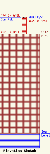
Site Elevation: 402.3 meters (1320 ft) |
| Height of Structure: 68 meters (223 feet) |
| Overall Height Above Ground: 68 meters (223 feet) |
| Overall Height Above Mean Sea Level: 470.3 meters (1543 feet) |
| WRGB C/R Height Above Mean Sea Level: 462.3 meters (1517 ft)
|
| Owner Info | Capital Media Corporation
30 Park Avenue
Troy, NY 12047
(518) 237-1330
paul.lotters@verizon.net |
| Contact Info | Professional Engineer
45 Sarah Drive
Avon, CT 06001
Charles Fitch
(860) 673-7260
fitchpe@comcast.net |
