|
|
Antenna Structure Registration 1210156 |
 |
Registration Info | Registration Number: 1210156 |
| File Number: A1297453 |
| FAA Study: 1994-ASW-844-OE |
| FAA Issue Date: 08/31/1994 |
| Status: Granted |
| Date Constructed: 07/07/1988 |
| NEPA: N |
Structure Info
| Structure Type: GTOWER |
| Structure Coordinates: 32-2-52.5 N 102-18-12.5 W (NAD 83) |
| Structure Coordinates: 32-02-52.1 N 102-18-11.0 W (Converted to NAD 27) |
| Structure Address: 2 Km West Of Junction Of State Roads #158 And #1788, Ector County, Near |
| Structure City: Odessa, TX |
| Structure County: Ector County |
| Painting & Lighting Info |
FAA Circular #: 70/7460-1G |
FAA Chapters: 3, 4, 5, 9 |
| Elevation Info |
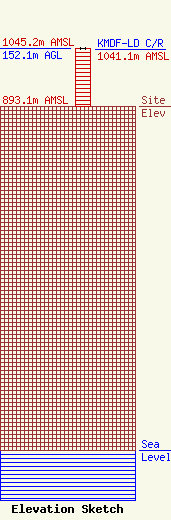
Site Elevation: 893.1 meters (2930 ft) |
| Height of Structure: 152.1 meters (499 feet) |
| Overall Height Above Ground: 152.1 meters (499 feet) |
| Overall Height Above Mean Sea Level: 1045.2 meters (3429 feet) |
| KMDF-LD C/R Height Above Mean Sea Level: 1041.1 meters (3416 ft)
|
| Owner Info | Gray Local Media, Inc.
4370 Peachtree Road, NE
Atlanta, GA 30319
(404) 266-8333
legalnotices@graymedia.com |
| Contact Info | Gray Local Media, Inc.
4370 Peachtree Road NE
Atlanta, GA 30319
Engineering Department
(404) 266-8333
legalnotices@graymedia.com |
