|
|
Antenna Structure Registration 1214756 |
 |
Registration Info | Registration Number: 1214756 |
| File Number: A1275518 |
| FAA Study: 2023-ANM-218-OE |
| FAA Issue Date: 02/15/2023 |
| Status: Constructed |
| Date Constructed: 04/29/2014 |
| NEPA: N |
Structure Info
| Structure Type: LTOWER |
| Structure Coordinates: 43-12-9.2 N 123-22-48.3 W (NAD 83) |
| Structure Coordinates: 43-12-09.8 N 123-22-44.0 W (Converted to NAD 27) |
| Structure Address: 2995 Military Avenue (308302 / Mt. Nebo) |
| Structure City: Roseburg, OR |
| Structure County: Douglas County |
| Painting & Lighting Info |
FAA Circular #: 70/7460-1J |
FAA Chapters: 4, 8, 13 |
Remarks: PRIOR STUDY 2014-ANM-1148-OE |
Remarks: OM&L to remain the same as prior study = A MED-DUAL SYSTEM |
Remarks: PRIOR STUDY 2014-ANM-1148-OE |
Remarks: OM&L to remain the same as prior study = A MED-DUAL SYSTEM |
| Elevation Info |
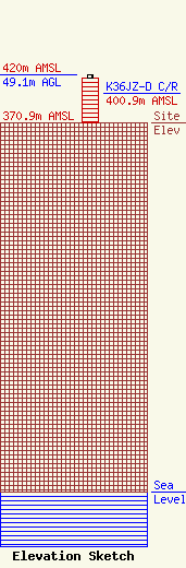
Site Elevation: 370.9 meters (1217 ft) |
| Height of Structure: 46 meters (151 feet) |
| Overall Height Above Ground: 49.1 meters (161 feet) |
| Overall Height Above Mean Sea Level: 420 meters (1378 feet) |
| K36JZ-D C/R Height Above Mean Sea Level: 400.9 meters (1315 ft)
|
| Owner Info | American Towers LLC
10 Presidential Way
Woburn, MA 01801
(781) 926-4500
faa-fcc@americantower.com |
| Contact Info | American Towers LLC
10 Presidential Way
Woburn, MA 01801
(781) 926-4500
faa-fcc@americantower.com |
