|
|
Antenna Structure Registration 1216075 |
 |
Registration Info | Registration Number: 1216075 |
| File Number: A1293021 |
| FAA Study: 2021-ASO-44410-OE |
| FAA Issue Date: 01/27/2023 |
| Status: Constructed |
| Date Constructed: 05/19/2008 |
| NEPA: N |
Structure Info
| Structure Type: GTOWER |
| Structure Coordinates: 35-15-5.5 N 80-41-11.2 W (NAD 83) |
| Structure Coordinates: 35-15-05.0 N 80-41-12.0 W (Converted to NAD 27) |
| Structure Address: 8036 Hood Road (#306397) |
| Structure City: Charlotte, NC |
| Structure County: Mecklenburg County |
| Painting & Lighting Info |
FAA Chapters: NONE |
Remarks: PRIOR STUDY 2007-ASO-4011-OE |
| Elevation Info |
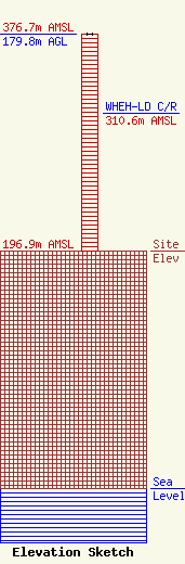
Site Elevation: 196.9 meters (646 ft) |
| Height of Structure: 179.8 meters (590 feet) |
| Overall Height Above Ground: 179.8 meters (590 feet) |
| Overall Height Above Mean Sea Level: 376.7 meters (1236 feet) |
| WHEH-LD C/R Height Above Mean Sea Level: 310.6 meters (1019 ft)
|
| Owner Info | American Towers LLC
10 Presidential Way
Woburn, MA 01801
(781) 926-4500
faa-fcc@americantower.com |
| Contact Info | American Towers LLC
10 Presidential Way
Woburn, MA 01801
(781) 926-4500
faa-fcc@americantower.com |
