|
|
Antenna Structure Registration 1220619 |
 |
Registration Info | Registration Number: 1220619 |
| File Number: A1063864 |
| FAA Study: 00-ANM-1596-OE |
| FAA Issue Date: 12/07/2000 |
| Status: Constructed |
| Date Constructed: 06/01/2001 |
| FAA EMI: N |
| NEPA: N |
Structure Info
| Structure Type: TOWER |
| Structure Coordinates: 42-20-30.0 N 122-54-36.0 W (NAD 83) |
| Structure Coordinates: 42-20-30.5 N 122-54-31.9 W (Converted to NAD 27) |
| Structure Address: 1440 Rossanley Dr |
| Structure City: Medford, OR |
| Structure County: Jackson County |
| Painting & Lighting Info |
FAA Chapters: NONE |
Remarks: Removed expiration date from determination. Scenario 1./jjs/case#635066 |
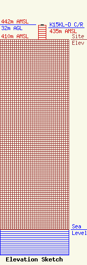
| Elevation Info |
Site Elevation: 410 meters (1345 ft) |
| Height of Structure: 30.5 meters (100 feet) |
| Overall Height Above Ground: 32 meters (105 feet) |
| Overall Height Above Mean Sea Level: 442 meters (1450 feet) |
| K15KL-D C/R Height Above Mean Sea Level: 435 meters (1427 ft)
|
| Owner Info | KTVL License, LLC
Pillsbury Winthrop Shaw Pittman LLP
Washington, DC 20036
(202) 663-8195
miles.mason@pillsburylaw.com |
| Contact Info | KTVL License, LLC
Pillsbury Winthrop Shaw Pittman LLP
Washington, DC 20036
(202) 663-8195
miles.mason@pillsburylaw.com |
