|
|
Antenna Structure Registration 1222113 |
 |
Registration Info | Registration Number: 1222113 |
| File Number: A0818156 |
| FAA Study: 2011-ANM-2710-OE |
| FAA Issue Date: 10/28/2011 |
| Status: Constructed |
| Date Constructed: 01/31/2000 |
| FAA EMI: N |
| NEPA: N |
Structure Info
| Structure Type: TOWER |
| Structure Coordinates: 44-11-52.2 N 120-58-44.2 W (NAD 83) |
| Structure Coordinates: 44-11-52.8 N 120-58-40.1 W (Converted to NAD 27) |
| Structure Address: Reservoir Road For Approx. 2.4 Miles (#75318) |
| Structure City: Powell Butte, OR |
| Structure County: Crook County |
| Painting & Lighting Info |
FAA Chapters: NONE |
Remarks: PRIOR STUDY 1999-ANM-2049-OE |
| Elevation Info |
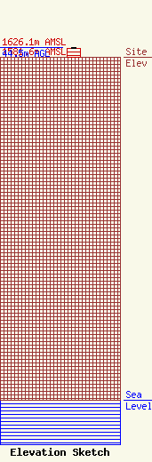
Site Elevation: 1581.6 meters (5189 ft) |
| Height of Structure: 39.9 meters (131 feet) |
| Overall Height Above Ground: 44.5 meters (146 feet) |
| Overall Height Above Mean Sea Level: 1626.1 meters (5335 feet) |
| K28MH-D C/R Height Above Mean Sea Level: 1587.6 meters (5209 ft)
|
| Owner Info | American Towers LLC
10 Presidential Way
Woburn, MA 01801
(678) 564-3236
faa-fcc@americantower.com |
| Contact Info | American Towers, LLC.
10 Presidential Way
Woburn, MA 01801
(678) 564-3236
faa-fcc@americantower.com |
