|
|
Antenna Structure Registration 1223132 |
 |
Registration Info | Registration Number: 1223132 |
| File Number: A1290576 |
| FAA Study: 2021-ASO-36490-OE |
| FAA Issue Date: 11/02/2021 |
| Status: Constructed |
| Date Constructed: 03/27/2002 |
Structure Info
| Structure Type: GTOWER |
| Structure Coordinates: 33-48-26.4 N 84-20-21.5 W (NAD 83) |
| Structure Coordinates: 33-48-26.0 N 84-20-21.8 W (Converted to NAD 27) |
| Structure Address: 1800 Briarcliff Road Ne (#282650) |
| Structure City: Atlanta, GA |
| Structure County: DeKalb County |
| Painting & Lighting Info |
FAA Circular #: 70/7460-1M |
FAA Chapters: 4, 9, 15 |
| Elevation Info |
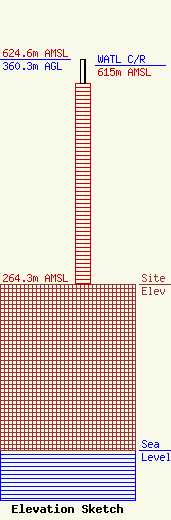
Site Elevation: 264.3 meters (867 ft) |
| Height of Structure: 321.9 meters (1056 feet) |
| Overall Height Above Ground: 360.3 meters (1182 feet) |
| Overall Height Above Mean Sea Level: 624.6 meters (2049 feet) |
| WATL C/R Height Above Mean Sea Level: 615 meters (2018 ft)
|
| Owner Info | American Towers LLC
10 Presidential Way
Woburn, MA 01801
(781) 926-4500
FAA-FCC@americantower.com |
| Contact Info | American Towers LLC
10 Presidential Way
Woburn, MA 01801
(781) 926-4500
FAA-FCC@americantower.com |
