|
|
Antenna Structure Registration 1223189 |
 |
Registration Info | Registration Number: 1223189 |
| File Number: A1281205 |
| FAA Study: 2023-ASO-5966-OE |
| FAA Issue Date: 07/24/2023 |
| Status: Constructed |
| Date Constructed: 04/08/2002 |
| NEPA: N |
Structure Info
| Structure Type: GTOWER |
| Structure Coordinates: 35-2-44.4 N 78-58-52.1 W (NAD 83) |
| Structure Coordinates: 35-02-43.8 N 78-58-53.0 W (Converted to NAD 27) |
| Structure Address: 6150 Raeford Road |
| Structure City: Fayetteville, NC |
| Structure County: Cumberland County |
| Painting & Lighting Info |
FAA Circular #: 70/7460-1L |
FAA Chapters: 4, 8, 12 |
Remarks: OM&L to remain the same as prior study = A MED-DUAL SYSTEM |
Remarks: PRIOR STUDY 2019-ASO-37372-OE |
Remarks: OM&L to remain the same as prior study = A MED-DUAL SYSTEM |
Remarks: PRIOR STUDY 2019-ASO-37372-OE |
| Elevation Info |
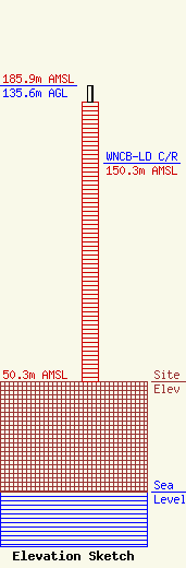
Site Elevation: 50.3 meters (165 ft) |
| Height of Structure: 128 meters (420 feet) |
| Overall Height Above Ground: 135.6 meters (445 feet) |
| Overall Height Above Mean Sea Level: 185.9 meters (610 feet) |
| WNCB-LD C/R Height Above Mean Sea Level: 150.3 meters (493 ft)
|
| Owner Info | Everest Special LLC
57 E Washington Street
Chagrin Falls, OH 44022
(440) 528-0333
rlepene@peppertreecapital.com |
| Contact Info | Everest Special LLC
57 E Washington Street
Chagrin Falls, OH 44022
Greg Thompson
(440) 528-0333
gthompson@everestspecial.com |
