|
|
Antenna Structure Registration 1223278 |
 |
Registration Info | Registration Number: 1223278 |
| File Number: A0979456 |
| FAA Study: 00-ANM-2182-OE |
| FAA Issue Date: 02/07/2001 |
| Status: Constructed |
| Date Constructed: 06/16/2005 |
| FAA EMI: N |
| NEPA: N |
Structure Info
| Structure Type: TOWER |
| Structure Coordinates: 47-41-40.6 N 117-20-4.7 W (NAD 83) |
| Structure Coordinates: 47-41-41.0 N 117-20-00.9 W (Converted to NAD 27) |
| Structure Address: Fancher Beacon |
| Structure City: Spokane, WA |
| Structure County: Spokane County |
| Painting & Lighting Info |
FAA Chapters: NONE |
Remarks: PRIOR STUDY 98-ANM-1131-OE |
| Elevation Info |
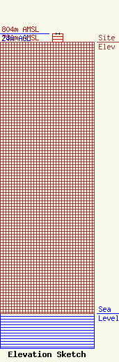
Site Elevation: 780 meters (2559 ft) |
| Height of Structure: 24 meters (79 feet) |
| Overall Height Above Ground: 24 meters (79 feet) |
| Overall Height Above Mean Sea Level: 804 meters (2638 feet) |
| KDYS-LD C/R Height Above Mean Sea Level: 799 meters (2621 ft)
|
| Owner Info | Day Management Corp. dba Day Wireless Systems
4700 SE International Way
Milwaukie, OR 97222
(503) 659-1240
dballew@daywireless.com |
| Contact Info | Day Management Corp. dba Day Wireless Systems
4700 SE International Way
Milwaukie, OR 97222
(503) 659-1240
dballew@daywireless.com |
