|
|
Antenna Structure Registration 1224260 |
 |
Registration Info | Registration Number: 1224260 |
| File Number: A1096626 |
| FAA Study: 01-AWP-1028-OE |
| FAA Issue Date: 03/21/2001 |
| Status: Constructed |
| Date Constructed: 08/01/2001 |
| FAA EMI: N |
| NEPA: N |
Structure Info
| Structure Type: TOWER |
| Structure Coordinates: 34-4-55.0 N 116-20-35.0 W (NAD 83) |
| Structure Coordinates: 34-04-55.0 N 116-20-32.0 W (Converted to NAD 27) |
| Structure Address: Joshua Tree Monument, End Of La Contenta Road |
| Structure City: Joshua Tree, CA |
| Structure County: San Bernardino County |
| Painting & Lighting Info |
FAA Circular #: 70/7460-1K |
FAA Chapters: 3, 4, 5, 12 |
Remarks: PRIOR STUDY 87-AWP-620-OE |
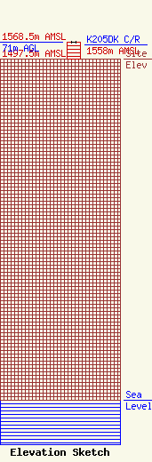
| Elevation Info |
Site Elevation: 1497.5 meters (4913 ft) |
| Height of Structure: 71 meters (233 feet) |
| Overall Height Above Ground: 71 meters (233 feet) |
| Overall Height Above Mean Sea Level: 1568.5 meters (5146 feet) |
| K205DK C/R Height Above Mean Sea Level: 1558 meters (5112 ft)
|
| Owner Info | VB-S1 Assets, LLC
750 Park of Commerce Dr.
Boca Raton, FL 33487
(561) 406-4015
FCC-FAA@verticalbridge.com |
| Contact Info | VB-S1 Assets, LLC
750 Park of Commerce Dr.
Boca Raton, FL 33487
Richard Hickey
(561) 406-4015
FCC-FAA@verticalbridge.com |
