|
|
Antenna Structure Registration 1225205 |
 |
Registration Info | Registration Number: 1225205 |
| File Number: A1133579 |
| FAA Study: 2013-ASW-73-OE |
| FAA Issue Date: 03/07/2013 |
| Status: Constructed |
| Date Constructed: 08/06/2001 |
| NEPA: N |
Structure Info
| Structure Type: LTOWER |
| Structure Coordinates: 35-12-49.8 N 106-27-3.3 W (NAD 83) |
| Structure Coordinates: 35-12-49.6 N 106-27-01.2 W (Converted to NAD 27) |
| Structure Address: 701 Sandia Crest Road (306762 / Sandia Crest 1) |
| Structure City: Albuquerque, NM |
| Structure County: Bernalillo County |
| Painting & Lighting Info |
FAA Circular #: 70/7460-1K |
FAA Chapters: 3, 4, 5, 12 |
Remarks: PRIOR STUDY 2012-ASW-2097-OE |
Remarks: OM&L to remain the same as prior study = PAINT/RED LIGHTS |
Remarks: PRIOR STUDY 2012-ASW-2097-OE |
Remarks: OM&L to remain the same as prior study = PAINT/RED LIGHTS |
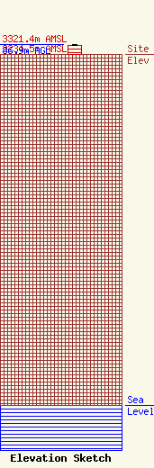
| Elevation Info |
Site Elevation: 3234.5 meters (10612 ft) |
| Height of Structure: 82.6 meters (271 feet) |
| Overall Height Above Ground: 86.9 meters (285 feet) |
| Overall Height Above Mean Sea Level: 3321.4 meters (10897 feet) |
| KNME-TV C/R Height Above Mean Sea Level: 3300.8 meters (10829 ft)
|
| Owner Info | SpectraSite Communications, LLC. through American Towers, LLC.
10 Presidential Way
Woburn, MA 01801
(678) 564-3236
faa-fcc@americantower.com |
| Contact Info | SpectraSite Communications, LLC. through American Towers, LLC.
10 Presidential Way
Woburn, MA 01801
(678) 564-3236
faa-fcc@americantower.com |
