|
|
Antenna Structure Registration 1226644 |
 |
Registration Info | Registration Number: 1226644 |
| File Number: A0948058 |
| FAA Study: 2015-ASO-2322-OE |
| FAA Issue Date: 03/24/2015 |
| Status: Constructed |
| Date Constructed: 07/10/2001 |
| NEPA: N |
Structure Info
| Structure Type: LTOWER |
| Structure Coordinates: 35-11-56.3 N 80-52-35.7 W (NAD 83) |
| Structure Coordinates: 35-11-55.8 N 80-52-36.4 W (Converted to NAD 27) |
| Structure Address: 3208 May Street (#274803) |
| Structure City: Charlotte, NC |
| Structure County: Mecklenburg County |
| Painting & Lighting Info |
FAA Circular #: 70/7460-1K |
FAA Chapters: 4, 8, 12 |
Remarks: PRIOR STUDY 2012-ASO-403-OE |
Remarks: OM&L to remain the same as prior study = A MED-DUAL SYSTEM |
Remarks: PRIOR STUDY 2012-ASO-403-OE |
| Elevation Info |
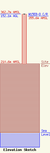
Site Elevation: 210.6 meters (691 ft) |
| Height of Structure: 150.6 meters (494 feet) |
| Overall Height Above Ground: 152.1 meters (499 feet) |
| Overall Height Above Mean Sea Level: 362.7 meters (1190 feet) |
| W15EB-D C/R Height Above Mean Sea Level: 355.6 meters (1167 ft)
|
| Owner Info | Global Tower, LLC. through American Towers, LLC
10 Presidential Way
Woburn, MA 01801
(678) 564-3236
faa-fcc@americantower.com |
| Contact Info | Global Tower, LLC. through American Towers, LLC
10 Presidential Way
Woburn, MA 01801
(678) 564-3236
faa-fcc@americantower.com |
