|
|
Antenna Structure Registration 1228608 |
 |
Registration Info | Registration Number: 1228608 |
| File Number: A1248331 |
| FAA Study: 2021-AEA-8972-OE |
| FAA Issue Date: 08/19/2021 |
| Status: Constructed |
| Date Constructed: 06/09/2008 |
| NEPA: N |
Structure Info
| Structure Type: LTOWER |
| Structure Coordinates: 43-8-5.5 N 77-35-5.7 W (NAD 83) |
| Structure Coordinates: 43-08-05.3 N 77-35-06.7 W (Converted to NAD 27) |
| Structure Address: 1 Pinnacle Hill Road (221268) |
| Structure City: Rochester, NY |
| Structure County: Monroe County |
| Painting & Lighting Info |
FAA Circular #: 70/7460-1M |
FAA Chapters: 4, 8, 15 |
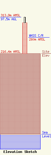
| Elevation Info |
Site Elevation: 216.4 meters (710 ft) |
| Height of Structure: 82.3 meters (270 feet) |
| Overall Height Above Ground: 97.5 meters (320 feet) |
| Overall Height Above Mean Sea Level: 313.9 meters (1030 feet) |
| WKGS C/R Height Above Mean Sea Level: 260 meters (853 ft)
|
| Owner Info | American Towers LLC
10 Presidential Way
Woburn, MA 01801
(781) 926-4500
FAA-FCC@americantower.com |
| Contact Info | American Towers LLC
10 Presidential Way
Woburn, MA 01801
(781) 926-4500
FAA-FCC@americantower.com |
