|
|
Antenna Structure Registration 1235873 |
 |
Registration Info | Registration Number: 1235873 |
| File Number: A1207434 |
| FAA Study: 2008-aso-2626-OE |
| FAA Issue Date: 06/02/2008 |
| Status: Constructed |
| Date Constructed: 01/30/2009 |
| FAA EMI: N |
| NEPA: N |
Structure Info
| Structure Type: TOWER |
| Structure Coordinates: 25-10-14.2 N 80-22-32.5 W (NAD 83) |
| Structure Coordinates: 25-10-12.8 N 80-22-33.3 W (Converted to NAD 27) |
| Structure Address: 809 Largo Road |
| Structure City: Key Largo, FL |
| Structure County: Monroe County |
| Painting & Lighting Info |
FAA Chapters: NONE |
Remarks: PRIOR STUDY 2002-ASO-3178-OE |
| Elevation Info |
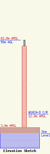
Site Elevation: 3.9 meters (13 ft) |
| Height of Structure: 55 meters (180 feet) |
| Overall Height Above Ground: 59 meters (194 feet) |
| Overall Height Above Mean Sea Level: 62.9 meters (206 feet) |
| W16CA-D C/R Height Above Mean Sea Level: 12.9 meters (42 ft)
|
| Owner Info | K2 Towers III, LLC
57 E Washington St
Chagrin Falls, OH 44022
(440) 528-0333
rlepene@peppertreecapital.com |
| Contact Info | K2 Towers III, LLC
57 E Washington St
Chagrin Falls, OH 44022
Greg Thompson
(440) 528-0333
gthompson@k2towers.com |
