|
|
Antenna Structure Registration 1236533 |
 |
Registration Info | Registration Number: 1236533 |
| File Number: A0802904 |
| FAA Study: 2011-ASO-5790-OE |
| FAA Issue Date: 10/19/2011 |
| Status: Constructed |
| Date Constructed: 08/27/2007 |
| FAA EMI: N |
| NEPA: N |
Structure Info
| Structure Type: TOWER |
| Structure Coordinates: 18-19-47.7 N 64-54-38.2 W (NAD 83) |
| Structure Coordinates: 18-19-54.9 N 64-54-39.7 W (Converted to NAD 27) |
| Structure Address: Flag Hill |
| Structure City: Charlotte Amali, VI |
| Structure County: St. Thomas Island |
| Painting & Lighting Info |
FAA Chapters: NONE |
Remarks: Removed expiration date from determination. Scenario 1./jjs/case#635066 |
Remarks: PRIOR STUDY 2003-ASO-4744-OE |
| Elevation Info |
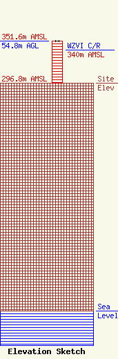
Site Elevation: 296.8 meters (974 ft) |
| Height of Structure: 54.8 meters (180 feet) |
| Overall Height Above Ground: 54.8 meters (180 feet) |
| Overall Height Above Mean Sea Level: 351.6 meters (1154 feet) |
| WZVI C/R Height Above Mean Sea Level: 340 meters (1115 ft)
|
| Owner Info | Royale Systems LLC
7188
St. Thomas, VI 00801
(340) 774-8082
bronxvi@yahoo.com |
