|
|
Antenna Structure Registration 1236903 |
 |
Registration Info | Registration Number: 1236903 |
| File Number: A0359846 |
| FAA Study: 2002-ASO-5513-OE |
| FAA Issue Date: 10/30/2002 |
| Status: Constructed |
| Date Constructed: 12/31/2003 |
| FAA EMI: N |
| NEPA: N |
Structure Info
| Structure Type: TOWER |
| Structure Coordinates: 34-12-17.9 N 88-41-49.6 W (NAD 83) |
| Structure Coordinates: 34-12-17.5 N 88-41-49.4 W (Converted to NAD 27) |
| Structure Address: 1 Mile East Of Us 45 Highway |
| Structure City: Verona, MS |
| Structure County: Lee County |
| Painting & Lighting Info |
FAA Circular #: 70/7460-1K |
FAA Chapters: 4, 6, 12 |
Remarks: SUPPLEMENTAL NOTICE STATES STRUCTURE REACHED GREATEST HEIGHT ON 12/03/2002 |
Remarks: Removed expiration date from determination. Scenario 1./jjs/case#635066 |
| Elevation Info |
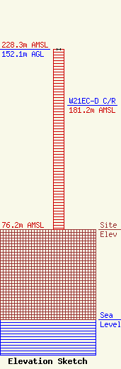
Site Elevation: 76.2 meters (250 ft) |
| Height of Structure: 152.1 meters (499 feet) |
| Overall Height Above Ground: 152.1 meters (499 feet) |
| Overall Height Above Mean Sea Level: 228.3 meters (749 feet) |
| W21EC-D C/R Height Above Mean Sea Level: 181.2 meters (594 ft)
|
| Owner Info | Moffatt Properties Leasing LLC
1960 McCullough Blvd
Tupelo, MS 38801
(662) 841-0059
chuck@selectconnect.net |
