|
|
Antenna Structure Registration 1237131 |
 |
Registration Info | Registration Number: 1237131 |
| File Number: A0300916 |
| FAA Study: 2002-ANM-1809-OE |
| FAA Issue Date: 10/16/2002 |
| Status: Granted |
| NEPA: N |
Structure Info
| Structure Type: TOWER |
| Structure Coordinates: 46-15-39.5 N 106-40-23.2 W (NAD 83) |
| Structure Coordinates: 46-15-39.5 N 106-40-21.1 W (Converted to NAD 27) |
| Structure Address: 0.5 Miles South Of Forsyth |
| Structure City: Forsyth, MT |
| Structure County: Rosebud County |
| Painting & Lighting Info |
FAA Circular #: |
FAA Chapters: NONE |
Remarks: Removed expiration date from determination. Scenario 1./jjs/case#635066 |
| Elevation Info |
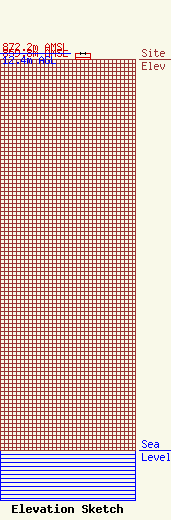
Site Elevation: 859.8 meters (2821 ft) |
| Height of Structure: 12.4 meters (41 feet) |
| Overall Height Above Ground: 12.4 meters (41 feet) |
| Overall Height Above Mean Sea Level: 872.2 meters (2862 feet) |
| K49MH-D C/R Height Above Mean Sea Level: 0 meters (0 ft)
|
| Owner Info | Forsyth T.V. Tax District
47
Forsyth, MT 59327
(406) 346-7608
rosebudweed@mcn.net |
| Contact Info | Burckhard Works
2020 Phoebe Drive
Billings, MT 59105
William Burckhard
(406) 248-9043
billb@khmt.com |
