|
|
Antenna Structure Registration 1237507 |
 |
Registration Info | Registration Number: 1237507 |
| File Number: A0789910 |
| FAA Study: 2011-ANM-1463-OE |
| FAA Issue Date: 08/21/2011 |
| Status: Constructed |
| Date Constructed: 10/01/2003 |
| FAA EMI: N |
| NEPA: N |
Structure Info
| Structure Type: LTOWER |
| Structure Coordinates: 40-57-33.5 N 109-25-1.5 W (NAD 83) |
| Structure Coordinates: 40-57-33.6 N 109-24-59.0 W (Converted to NAD 27) |
| Structure Address: Aprox 2 Miles North Of Dutch John, Utah |
| Structure City: Dutch John, UT |
| Structure County: Daggett County |
| Painting & Lighting Info |
FAA Chapters: NONE |
Remarks: PRIOR STUDY 2000-ANM-1275-OE |
| Elevation Info |
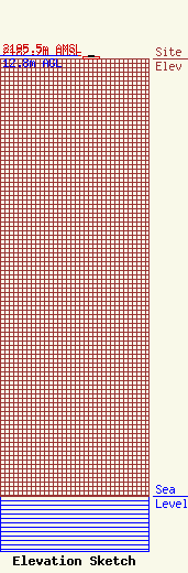
Site Elevation: 2182.7 meters (7161 ft) |
| Height of Structure: 7.3 meters (24 feet) |
| Overall Height Above Ground: 12.8 meters (42 feet) |
| Overall Height Above Mean Sea Level: 2195.5 meters (7203 feet) |
| K35KL-D C/R Height Above Mean Sea Level: 2188.1 meters (7179 ft)
|
| Owner Info | University of Utah
101 South Wasatch Drive
Salt Lake City, UT 84112
(801) 585-3601
ptitus@media.utah.edu |
| Contact Info | University of Utah
101 South Wasatch Drive
Salt Lake City, UT 84112
Philip Titus
(801) 585-3601
ptitus@kued.org |
