|
|
Antenna Structure Registration 1240846 |
 |
Registration Info | Registration Number: 1240846 |
| File Number: A0909283 |
| FAA Study: 2006-AGL-1205-OE |
| FAA Issue Date: 03/30/2006 |
| Status: Constructed |
| Date Constructed: 07/01/1973 |
| FAA EMI: N |
| NEPA: N |
Structure Info
| Structure Type: TOWER |
| Structure Coordinates: 42-28-35.0 N 85-29-4.8 W (NAD 83) |
| Structure Coordinates: 42-28-34.9 N 85-29-04.8 W (Converted to NAD 27) |
| Structure Address: 12915 Enzian Road |
| Structure City: Prairieville, MI |
| Structure County: Barry County |
| Painting & Lighting Info |
FCC Paragraph(s): 1, 3, 6, 15, 21 |
Remarks: RED LIGHTS/PAINT. PRIOR FAA 1984-AGL-606-OE. |
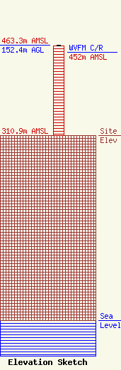
| Elevation Info |
Site Elevation: 310.9 meters (1020 ft) |
| Height of Structure: 151.5 meters (497 feet) |
| Overall Height Above Ground: 152.4 meters (500 feet) |
| Overall Height Above Mean Sea Level: 463.3 meters (1520 feet) |
| WVFM C/R Height Above Mean Sea Level: 452 meters (1483 ft)
|
| Owner Info | Midwest Communications, Inc.
904 Grand Avenue
Wausau, WI 54403
(715) 842-1437
paul.rahmlow@mwcradio.com |
| Contact Info | Midwest Communications, Inc.
904 Grand Avenue
Wausau, WI 54403
Paul Rahmlow
(715) 842-1437
paul.rahmlow@mwcradio.com |
