|
|
Antenna Structure Registration 1243417 |
 |
Registration Info | Registration Number: 1243417 |
| File Number: A0944568 |
| FAA Study: 2007-ASO-2952-OE |
| FAA Issue Date: 06/29/2007 |
| Status: Constructed |
| Date Constructed: 10/06/2005 |
| NEPA: N |
Structure Info
| Structure Type: GTOWER |
| Structure Coordinates: 32-19-16.4 N 84-47-28.2 W (NAD 83) |
| Structure Coordinates: 32-19-15.9 N 84-47-28.5 W (Converted to NAD 27) |
| Structure Address: 135 Hwy. 26 |
| Structure City: Cusseta, GA |
| Structure County: Chattahoochee County |
| Painting & Lighting Info |
FAA Circular #: 70/7460-1K |
FAA Chapters: 4, 9, 12 |
Remarks: PRIOR STUDY 2001-ASO-3028-OE |
Remarks: OM&L to remain the same as prior study = A HIGH-DUAL SYSTEM |
Remarks: PRIOR STUDY 2001-ASO-3028-OE |
Remarks: OM&L to remain the same as prior study = A HIGH-DUAL SYSTEM |
| Elevation Info |
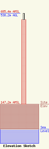
Site Elevation: 147.2 meters (483 ft) |
| Height of Structure: 500.7 meters (1643 feet) |
| Overall Height Above Ground: 538.2 meters (1766 feet) |
| Overall Height Above Mean Sea Level: 685.4 meters (2249 feet) |
| Owner Info | American Towers LLC
10 Presidential Way
Woburn, MA 01801
(678) 564-3236
FAA-FCC@americantower.com |
| Contact Info | American Tower, LLC
10 Presidential Way
Woburn, MA 01801
Julie Kim
(678) 564-3236
FAA-FCC@americantower.com |
