|
|
Antenna Structure Registration 1243489 |
 |
Registration Info | Registration Number: 1243489 |
| File Number: A1198573 |
| FAA Study: 2020-ASO-36249-OE |
| FAA Issue Date: 04/02/2021 |
| Status: Constructed |
| Date Constructed: 08/17/2005 |
| NEPA: N |
Structure Info
| Structure Type: GTOWER |
| Structure Coordinates: 36-22-51.5 N 83-10-49.4 W (NAD 83) |
| Structure Coordinates: 36-22-51.2 N 83-10-49.8 W (Converted to NAD 27) |
| Structure Address: Bulls Gap |
| Structure City: Bulls Gap, TN |
| Structure County: Hawkins County |
| Painting & Lighting Info |
FAA Circular #: 70/7460-1M |
FAA Chapters: 4, 8, 15 |
Remarks: PRIOR STUDY 2003-ASO-6980-OE |
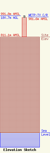
| Elevation Info |
Site Elevation: 811.1 meters (2661 ft) |
| Height of Structure: 164.6 meters (540 feet) |
| Overall Height Above Ground: 180.7 meters (593 feet) |
| Overall Height Above Mean Sea Level: 991.8 meters (3254 feet) |
| WETP-TV C/R Height Above Mean Sea Level: 981.6 meters (3220 ft)
|
| Owner Info | East Tennessee Public Communications Corp.
1611 East Magnolia Avenue
Knoxville, TN 37917
(865) 595-0220
tony@easttennesseepbs.org |
| Contact Info | East Tennessee Public Communications
1611 E. Magnolia Ave
P.O. Box 550
Knoxville, TN 37917
Tony Poole
(865) 595-0225
tony@easttennesseepbs.org |
