|
|
Antenna Structure Registration 1245964 |
 |
Registration Info | Registration Number: 1245964 |
| File Number: A1212697 |
| FAA Study: 2004-ASO-1041-OE |
| FAA Issue Date: 04/26/2004 |
| Status: Constructed |
| Date Constructed: 03/02/2005 |
| FAA EMI: N |
| NEPA: N |
Structure Info
| Structure Type: TOWER |
| Structure Coordinates: 28-53-2.2 N 82-31-20.1 W (NAD 83) |
| Structure Coordinates: 28-53-01.3 N 82-31-20.7 W (Converted to NAD 27) |
| Structure Address: 1450 North Knoll Road |
| Structure City: Lecanto, FL |
| Structure County: Citrus County |
| Painting & Lighting Info |
FAA Circular #: 70/7460-1K |
FAA Chapters: 4, 8, 12 |
Remarks: Removed expiration and final dates from determination. Scenario 2./jjs/case#635066 |
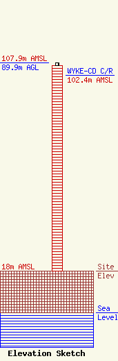
| Elevation Info |
Site Elevation: 18 meters (59 ft) |
| Height of Structure: 88.7 meters (291 feet) |
| Overall Height Above Ground: 89.9 meters (295 feet) |
| Overall Height Above Mean Sea Level: 107.9 meters (354 feet) |
| WYKE-CD C/R Height Above Mean Sea Level: 102.4 meters (336 ft)
|
| Owner Info | Christian Television Corporation, Inc.
6922 142nd Ave. N.
Largo, FL 33771
(727) 535-5622
hugh@ctntv.org |
| Contact Info | Christian Television Corporation, Inc.
6922 142nd Ave N.
Largo, FL 33771
Hugh Allegood
(727) 535-5622
hugh@ctntv.org |
