|
|
Antenna Structure Registration 1251249 |
 |
Registration Info | Registration Number: 1251249 |
| File Number: A0533830 |
| FAA Study: 2005-ANE-1102-OE |
| FAA Issue Date: 11/28/2005 |
| Status: Constructed |
| Date Constructed: 11/01/2005 |
| FAA EMI: N |
| NEPA: N |
Structure Info
| Structure Type: BANT |
| Structure Coordinates: 42-20-50.0 N 71-4-57.0 W (NAD 83) |
| Structure Coordinates: 42-20-49.6 N 71-04-58.8 W (Converted to NAD 27) |
| Structure Address: Prudential Building |
| Structure City: Boston, MA |
| Structure County: Suffolk County |
| Painting & Lighting Info |
FAA Circular #: 70/7460-1K |
FAA Chapters: 4, 5, 12 |
Remarks: OM&L to remain the same as prior study = RED LIGHTS |
Remarks: PRIOR STUDY 2003-ANE-292-OE |
Remarks: OM&L to remain the same as prior study = RED LIGHTS |
Remarks: PRIOR STUDY 2003-ANE-292-OE |
| Elevation Info |
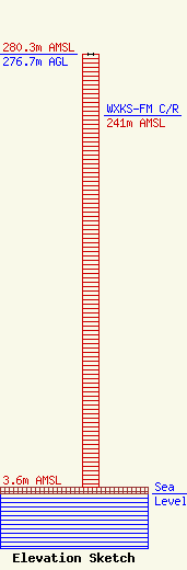
Site Elevation: 3.6 meters (12 ft) |
| Height of Structure: 276.7 meters (908 feet) |
| Overall Height Above Ground: 276.7 meters (908 feet) |
| Overall Height Above Mean Sea Level: 280.3 meters (920 feet) |
| WXKS-FM C/R Height Above Mean Sea Level: 241 meters (791 ft)
|
| Owner Info | BOSTON FIRE DEPARTMENT
59 FENWAY
BOSTON, MA 02115
(617) 725-2875
|
| Contact Info | UNITED STATES LICENSING
607 EL MAR DRIVE
ROCHESTER, NY 14616-1035
GARY PERKINS
(585) 621-4599
gary@4fcchelp.com |
