|
|
Antenna Structure Registration 1253768 |
 |
Registration Info | Registration Number: 1253768 |
| File Number: A0875128 |
| FAA Study: 2006-ACE-1149-OE |
| FAA Issue Date: 06/02/2006 |
| Status: Constructed |
| Date Constructed: 01/17/2014 |
| FAA EMI: N |
| NEPA: N |
Structure Info
| Structure Type: TOWER |
| Structure Coordinates: 40-24-40.1 N 91-24-14.5 W (NAD 83) |
| Structure Coordinates: 40-24-39.9 N 91-24-14.0 W (Converted to NAD 27) |
| Structure Address: West Side Of Mckinley Avenue Between Belknap Place And Johnson Street Road |
| Structure City: Keokuk, IA |
| Structure County: Lee County |
| Painting & Lighting Info |
FAA Chapters: NONE |
| Elevation Info |
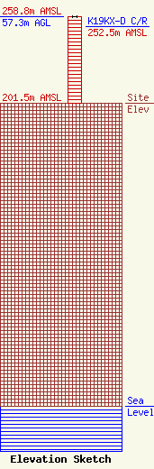
Site Elevation: 201.5 meters (661 ft) |
| Height of Structure: 57.3 meters (188 feet) |
| Overall Height Above Ground: 57.3 meters (188 feet) |
| Overall Height Above Mean Sea Level: 258.8 meters (849 feet) |
| K19KX-D C/R Height Above Mean Sea Level: 252.5 meters (828 ft)
|
| Owner Info | Iowa Public Broadcast Board
6450
Johnston, IA 50131-6450
(515) 242-3116
hayes@iptv.org |
| Contact Info | Iowa Public Television
6450
Johnston, IA 50131
William Hayes
(515) 242-3116
hayes@iptv.org |
