|
|
Antenna Structure Registration 1257714 |
 |
Registration Info | Registration Number: 1257714 |
| File Number: A0549762 |
| FAA Study: 2005-AEA-1421-OE |
| FAA Issue Date: 03/23/2007 |
| Status: Constructed |
| Date Constructed: 05/15/2007 |
| FAA EMI: N |
| NEPA: N |
Structure Info
| Structure Type: TOWER |
| Structure Coordinates: 37-47-13.7 N 81-6-49.5 W (NAD 83) |
| Structure Coordinates: 37-47-13.3 N 81-06-50.1 W (Converted to NAD 27) |
| Structure Address: 162 Industrial Park Rd |
| Structure City: Beaver, WV |
| Structure County: Raleigh County |
| Painting & Lighting Info |
FAA Circular #: 70/7460-1K |
FAA Chapters: 4, 5, 12 |
Remarks: PRIOR STUDY 2001-AEA-4466-OE |
Remarks: Removed expiration date from determination. Scenario 1./jjs/case#635066 |
| Elevation Info |
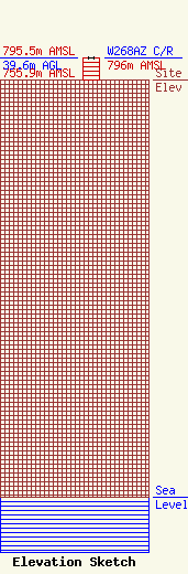
Site Elevation: 755.9 meters (2480 ft) |
| Height of Structure: 39.6 meters (130 feet) |
| Overall Height Above Ground: 39.6 meters (130 feet) |
| Overall Height Above Mean Sea Level: 795.5 meters (2610 feet) |
| W268AZ C/R Height Above Mean Sea Level: 796 meters (2612 ft)
|
| Owner Info | RALEIGH CO EMERGENCY SERVICES/911
340 PRINCE ST
5513
BECKLEY, WV 25802
(304) 255-0911
raleigh911@suddenlinkmail.com |
