|
|
Antenna Structure Registration 1258591 |
 |
Registration Info | Registration Number: 1258591 |
| File Number: A1315491 |
| FAA Study: 2022-ANM-5364-OE |
| FAA Issue Date: 12/12/2022 |
| Status: Constructed |
| Date Constructed: 06/30/2024 |
| NEPA: N |
Structure Info
| Structure Type: LTOWER |
| Structure Coordinates: 47-32-27.0 N 115-19-5.0 W (NAD 83) |
| Structure Coordinates: 47-32-27.2 N 115-19-01.5 W (Converted to NAD 27) |
| Structure Address: Clark Mtn. |
| Structure City: Thompson Falls, MT |
| Structure County: Sanders County |
| Painting & Lighting Info |
FAA Chapters: NONE |
Remarks: PRIOR STUDY 2007-ANM-1282-OE |
| Elevation Info |
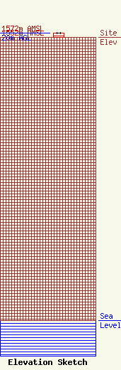
Site Elevation: 1552 meters (5092 ft) |
| Height of Structure: 20 meters (66 feet) |
| Overall Height Above Ground: 20 meters (66 feet) |
| Overall Height Above Mean Sea Level: 1572 meters (5157 feet) |
| K04QV-D C/R Height Above Mean Sea Level: 1562.2 meters (5125 ft)
|
| Owner Info | Western Sanders County TV District
519
Thompson Falls, MT 59873
(406) 827-4100
duffel@blackfoot.net |
| Contact Info | Western Sanders County TV District
519
Thompson Falls, MT 59873
Dewey Duffel
(406) 827-4100
duffel@blackfoot.net |
