|
|
Antenna Structure Registration 1269722 |
 |
Registration Info | Registration Number: 1269722 |
| File Number: A0663103 |
| FAA Study: 2009-ANM-1121-OE |
| FAA Issue Date: 08/03/2009 |
| Status: Constructed |
| Date Constructed: 08/05/2009 |
| FAA EMI: N |
| NEPA: N |
Structure Info
| Structure Type: TOWER |
| Structure Coordinates: 37-3-34.6 N 112-31-12.2 W (NAD 83) |
| Structure Coordinates: 37-03-34.7 N 112-31-09.5 W (Converted to NAD 27) |
| Structure Address: Mountain North Northeast Of Kanab. 2.9 Miles From Kanab Municipal @ 15 Deg. |
| Structure City: Kanag, UT |
| Structure County: Kane County |
| Painting & Lighting Info |
FAA Chapters: NONE |
| Elevation Info |
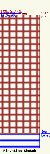
Site Elevation: 1759 meters (5771 ft) |
| Height of Structure: 19.5 meters (64 feet) |
| Overall Height Above Ground: 19.5 meters (64 feet) |
| Overall Height Above Mean Sea Level: 1778.5 meters (5835 feet) |
| K23DP-D C/R Height Above Mean Sea Level: 1774 meters (5820 ft)
|
| Owner Info | Western Kane County Special Service District
36
Kanab, UT 84741
Nyle Willis
(435) 644-5089
nww@kanab.net |
