|
|
Antenna Structure Registration 1270180 |
 |
Registration Info | Registration Number: 1270180 |
| File Number: A1135255 |
| FAA Study: 2009-ANM-1460-OE |
| FAA Issue Date: 08/27/2009 |
| Status: Constructed |
| Date Constructed: 09/02/2009 |
| FAA EMI: N |
| NEPA: N |
Structure Info
| Structure Type: TOWER |
| Structure Coordinates: 45-45-56.5 N 108-27-26.6 W (NAD 83) |
| Structure Coordinates: 45-45-56.7 N 108-27-24.1 W (Converted to NAD 27) |
| Structure Address: 1700 Coburn Road, Sacrifice Cliffs Antenna Farm |
| Structure City: Billings, MT |
| Structure County: Yellowstone County |
| Painting & Lighting Info |
FAA Chapters: NONE |
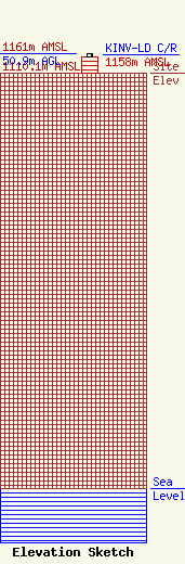
| Elevation Info |
Site Elevation: 1110.1 meters (3642 ft) |
| Height of Structure: 43.9 meters (144 feet) |
| Overall Height Above Ground: 50.9 meters (167 feet) |
| Overall Height Above Mean Sea Level: 1161 meters (3809 feet) |
| KINV-LD C/R Height Above Mean Sea Level: 1158 meters (3799 ft)
|
| Owner Info | Scripps Broadcasting Holdings LLC
312 Walnut Street
Cincinnati, OH 45202
(513) 977-3000
dave.giles@scripps.com |
| Contact Info | Baker & Hostetler LLP
1050 Connecticut Ave., NW
Washington, DC 20036
Kenneth Howard
(202) 861-1580
khoward@bakerlaw.com |
