|
|
Antenna Structure Registration 1303366 |
 |
Registration Info | Registration Number: 1303366 |
| File Number: A1313140 |
| FAA Study: 2017-ANM-958-OE |
| FAA Issue Date: 05/02/2017 |
| Status: Constructed |
| Date Constructed: 12/22/2017 |
Structure Info
| Structure Type: LTOWER |
| Structure Coordinates: 41-8-16.4 N 104-46-51.5 W (NAD 83) |
| Structure Coordinates: 41-08-16.5 N 104-46-49.6 W (Converted to NAD 27) |
| Structure Address: 2923 E. Lincolnway |
| Structure City: Cheyenne, WY |
| Structure County: Laramie County |
| Painting & Lighting Info |
FAA Chapters: NONE |
Remarks: Removed expiration date from determination. Scenario 1./jjs/case#635066 |
Remarks: PRIOR STUDY 2000-ANM-84-OE |
Remarks: Removed expiration date from determination. Scenario 1./jjs/case#635066 |
Remarks: PRIOR STUDY 2000-ANM-84-OE |
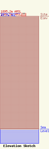
| Elevation Info |
Site Elevation: 1849.5 meters (6068 ft) |
| Height of Structure: 45.7 meters (150 feet) |
| Overall Height Above Ground: 45.7 meters (150 feet) |
| Overall Height Above Mean Sea Level: 1895.2 meters (6218 feet) |
| Owner Info | Marquee Broadcasting West, Inc.
2923 East Lincolnway
Cheyenne, WY 82001
(301) 661-9610
patricia_lane@marqueebroadcasting.com |
| Contact Info | BakerHostetler LLP
1050 Connecticut Ave NW
Washington, DC 20036
Daniel Kirkpatrick
(202) 861-1758
dkirkpatrick@bakerlaw.com |
