|
W253CC Channel: 253D 98.5 MHz
Bethlehem, Pennsylvania
Service: FX - A translator or application for a translator.
Facility ID: 21198
FRN: 0024667834
Fac. Service: FX
Programming Delivery Method: Unspecified
Status: LIC
Application Accepted: 05/17/2019
Application Granted: 05/22/2019
File Number: BLFT-20190517ABD
License Expires: 08/01/2030
Prefix Type: This is a license for a translator
Application Type: License To Cover
FCC Website Links:
LMS Facility Details
This Application
Other W253CC Applications
Including Superseded Applications
Service Contour - Open Street Map or USGS Map (60 dBu)
Service Contour - KML / Google Earth (60 dBu)
Facility Type: FM STATION
Class: D, A Noncommercial educational operating with no more than 10W
Site Location: 40-37-27.4 N 75-21-17.6 W (NAD 83)
Site Location: 40-37-27.0 N 75-21-19.0 W (Converted to NAD 27)
Effective Radiated Power: 0.25 kW Horiz. ; 0 kW Vert.
Transmitter Output Power: 0.271 kW
Antenna Center AMSL: 159 m Horiz.; 0 m Vert.
Antenna Center HAG: 61 m Horiz.; 0 m Vert.
Site Elevation: 98 m. (322 ft.)
Height Overall*: 70 m (230 ft.)
(* As Filed In This Application, may differ from ASR Data, Below.)
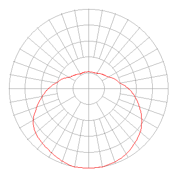
Directional Antenna
Antenna Make/Model: OMB YAV-3
Antenna ID: 133348
Polarization:
| Primary Station |
| WGPA(AM) |
Ch. 0 | Bethlehem, Pennsylvania |
|
Structure Information
Structure Registration Number 1241176
[ASR Heights Differ from W253CC Application]
Structure Type: TOWER
Registered To:
CC Broadcasting, LLC
Structure Address:
Jennings & Market Street
Bethlehem, PA
County Name: Northampton County
ASR Issued: 06/09/2015
Date Built: 11/17/1975
Site Elevation: 97.5 m (320 ft.)
Structure Height: 68.6 m (225 ft.)
Height Overall: 69.8 m (229 ft.)
Overall Height AMSL: 167.3 m (549 ft.)
FAA Determination: 08/21/1964
FAA Study #: EA-OE-5811
Paint & Light FAA Chapters: 1, 3, 11, 21
RED LIGHTS/PAINT
40-37-27.4 N 75-21-17.6 W (NAD 83)
40-37-27.0 N 75-21-19.0 W
(Converted to NAD 27)
|
W253CC(FX) Licensee Information
CC Broadcasting, LLC
144 Noble Street
Kutztown, PA 19530
Phone: 610-683-6369
| 20190517ABD Applicant Information
Ronald O, Crumbliss
Date: 05/17/2019
Application Certifier
CC Broadcasting, LLC
144 Noble Street
Kutztown, PA 19530
Applicant
Christopher Crumbliss
144 Noble Street
Kutztown, PA 19530
Manager/Chief Operator
Dennis J. Kelly
Law Office of Dennis J. Kelly
Post Office Box 41177
Washington, DC 20018-0577
|