|
W273DD Channel: 273D 102.5 MHz
Grand Rapids, Michigan
Service: FX - A translator or application for a translator.
Facility ID: 145316
FRN: 0002753655
Fac. Service: FX
Programming Delivery Method: Unspecified
Status: LIC
Application Accepted: 02/22/2017
Application Granted: 03/07/2017
File Number: BLFT-20170222ABT
License Expires: 10/01/2028
Prefix Type: This is a license for a translator
Application Type: License To Cover
FCC Website Links:
LMS Facility Details
This Application
Other W273DD Applications
Including Superseded Applications
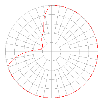
Service Contour - Open Street Map or USGS Map (60 dBu)
Service Contour - KML / Google Earth (60 dBu)
Class: D, A Noncommercial educational operating with no more than 10W
Site Location: 43-01-58.1 N 85-41-47.1 W (NAD 83)
Site Location: 43-01-58.0 N 85-41-47.0 W (Converted to NAD 27)
Effective Radiated Power: 0.155 kW
Transmitter Output Power: 0.071 kW
Antenna Center AMSL: 316 m (1037 ft.)
Antenna Center HAG: 66 m (217 ft.)
Site Elevation: 250 m. (820 ft.)
Height Overall*: 151 m (495 ft.)
(* As Filed In This Application, may differ from ASR Data, Below.)
Directional Antenna
Antenna Make/Model: NIC BKY3/P-1DA(SLANT45)
Antenna ID: 126553
Polarization:
| Primary Station |
| WPRR(AM) |
Ch. 0 | Ada, Michigan |
|
Structure Information
Structure Registration Number 1063467
Structure Type: GTOWER
Registered To:
TOWNSQUARE MEDIA OF GRAND RAPIDS, INC.
Structure Address:
Cordes Ave
Walker, MI
County Name: Kent County
ASR Issued: 03/18/2021
Date Built: 03/10/2014
Site Elevation: 250 m (820 ft.)
Structure Height: 135 m (443 ft.)
Height Overall: 151 m (495 ft.)
Overall Height AMSL: 401 m (1316 ft.)
FAA Determination: 02/03/2014
FAA Study #: 2014-AGL-131-OE
Paint & Light FAA Chapters: 1, 3, 4, 13, 21
PRIOR STUDY 1982-AGL-2332-OE. FAA approves Bird Lighting Deviation for RED LIGHTS/PAINT
43-01-58.0 N 85-41-47.0 W (NAD 83)
43-01-57.9 N 85-41-46.9 W
(Converted to NAD 27)
|
W273DD(FX) Licensee Information
Goodrich Radio, LLC
4417 Broadmoor SE
Kentwood, MI 49512
Phone: 616-698-7733
| 20170222ABT Applicant Information
Robert Emmett Goodrich
Date: 02/22/2017
Application Certifier
Goodrich Radio LLC
4417 Broadmoor SE
Kentwood, MI 49512
Applicant
Edmond R Trombley
Munn-Reese
POB 220
Coldwater, MI 49036
Technical Consultant
James A. Koerner, Esq.
Koerner & Olender, P.C.
7020 Richard Drive
Bethesda, MD 20817
|