FCCInfo.com
A Service of Cavell, Mertz & Associates, Inc.
(855) FCC-INFO
|
|
K09YI-D from 01/12/2007 |
|
|
||||||||||||||||
|
|
Status: LIC (Licensed And Silent) Application Accepted: 04/21/2025 License Expires: 10/01/2030 File Number: 0000269735 FCC Website Links: LMS Facility Details This Application Other KOPA-CD Applications Including Superseded Applications Service Contour - Open Street Map or USGS Map (48 dBu) Service Contour - KML / Google Earth (48 dBu) Public Inspection Files Rabbit Ears Info Search for KOPA-CD Site Location: 44-14-35.0 N 105-32-21.0 W (NAD 83) Site Location: 44-14-35.1 N 105-32-19.0 W (Converted to NAD 27) ERP: 0.3 kW Polarization: Horizontally polarized R/C AGL: 66 m (217 ft.) R/C AMSL: 1532 m (5026 ft.) Emission Mask: Stringent Site Elevation: 1466 m. (4810 ft.) Height Overall*: 152 m (499 ft.) (* As Filed In This Application, may differ from ASR Data, Below.) Directional Antenna - Antenna Make/Model: Scala DRV-1/3HC Antenna ID: 1012714 Polarization: Horizontally polarized | ||||||||||||||||||
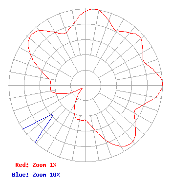
| Antenna Data for Antenna Id: 1012714 KOPA-CD DC File: -0000269735 Scala - DRV-1/3HC Service: DC Standard Pattern: N Pattern and Field Values Include a 48° Clockwise Rotation |  | ||||||||||||||||||
| Azimuth | Ratio | Azimuth | Ratio | Azimuth | Ratio | Azimuth | Ratio | ||||||||||||
| 8 | 1.000 | 18 | 0.914 | 28 | 0.818 | 38 | 0.877 | ||||||||||||
| 48 | 0.945 | 58 | 0.877 | 68 | 0.818 | 78 | 0.914 | ||||||||||||
| 88 | 1.000 | 98 | 0.944 | 108 | 0.805 | 118 | 0.726 | ||||||||||||
| 128 | 0.821 | 138 | 0.947 | 148 | 0.941 | 158 | 0.801 | ||||||||||||
| 168 | 0.604 | 178 | 0.470 | 188 | 0.460 | 198 | 0.437 | ||||||||||||
| 208 | 0.299 | 218 | 0.136 | 228 | 0.058 | 238 | 0.136 | ||||||||||||
| 248 | 0.299 | 258 | 0.438 | 268 | 0.460 | 278 | 0.469 | ||||||||||||
| 288 | 0.604 | 298 | 0.801 | 308 | 0.941 | 318 | 0.947 | ||||||||||||
| 328 | 0.821 | 338 | 0.727 | 348 | 0.804 | 358 | 0.944 | ||||||||||||
Structure Registration Number 1009813 Structure Type: TOWER Registered To: Legend Communications of Wyoming, LLC Structure Address: Sw 1/4 Of Sect 8 T49n R72w Campbell County Gillette, WY County Name: Campbell County ASR Issued: 10/03/2007 Date Built: 09/01/1982 Site Elevation: 1466 m (4810 ft.) Structure Height: 151 m (495 ft.) Height Overall: 152 m (499 ft.) Overall Height AMSL: 1618 m (5308 ft.) FAA Determination: 09/10/1982 FAA Study #: 80-ARM-347-OE FAA Circular #: 70/7460-1F Paint & Light FAA Chapters: 3, 5, 9 44-14-35.0 N 105-32-21.0 W (NAD 83) 44-14-35.1 N 105-32-19.0 W (Converted to NAD 27) |
4370 Peachtree Road, NE Atlanta, GA 30319 Phone: 404-504-9828 Limited Liability Company | Title: Assistant Secretary Date: 04/21/2025 Application Certifier Gray Television Licensee, LLC 4370 Peachtree Road, NE Atlanta, GA 30319 Applicant Joan Stewart Wiley Rein LLP 2050 M Street, NW Washington, DC 20036 | |||||||||||||||||