FCCInfo.com
A Service of Cavell, Mertz & Associates, Inc.
(855) FCC-INFO
|
|
KVKV-LP from 04/24/2006 KMXU-LP from 08/04/2005 K29GW from 07/28/2005 |
|
|
||||||||||||||||
|
|
Status: LIC Application Accepted: 06/01/2018 License Expires: 12/01/2022 File Number: 0000054931 FCC Website Links: LMS Facility Details This Application Other DKVKV-LP Applications Including Superseded Applications Service Contour - Open Street Map or USGS Map (74 dBu) Service Contour - KML / Google Earth (74 dBu) Public Inspection Files Rabbit Ears Info Search for DKVKV-LP Site Location: 34-36-43.6 N 117-17-32.1 W (NAD 83) Site Location: 34-36-43.6 N 117-17-28.9 W (Converted to NAD 27) ERP: 1 kW R/C AGL: 49 m (161 ft.) R/C AMSL: 1379.8 m (4527 ft.) Site Elevation: 1330.8 m. (4366 ft.) Height Overall*: 59.4 m (195 ft.) (* As Filed In This Application, may differ from ASR Data, Below.) Directional Antenna - Antenna Make/Model: Scala PR-450 ARRAY Antenna ID: 88451 | ||||||||||||||||||
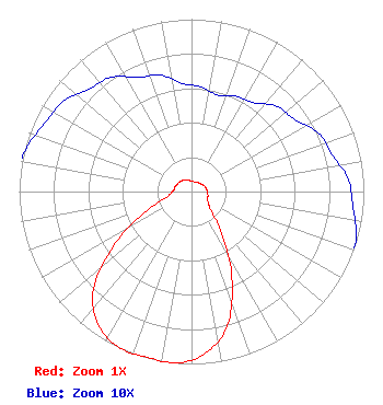
| Antenna Data for Antenna Id: 88451 DKVKV-LP TX File: -0000054931 Scala - PR-450 ARRAY Service: TX Standard Pattern: Y Pattern and Field Values Include a 195° Clockwise Rotation |  | ||||||||||||||||||
| Azimuth | Ratio | Azimuth | Ratio | Azimuth | Ratio | Azimuth | Ratio | ||||||||||||
| 5 | 0.061 | 15 | 0.058 | 25 | 0.061 | 35 | 0.063 | ||||||||||||
| 45 | 0.070 | 55 | 0.073 | 65 | 0.081 | 75 | 0.084 | ||||||||||||
| 85 | 0.091 | 95 | 0.094 | 105 | 0.099 | 115 | 0.103 | ||||||||||||
| 125 | 0.121 | 135 | 0.164 | 145 | 0.318 | 155 | 0.554 | ||||||||||||
| 165 | 0.805 | 175 | 0.942 | 185 | 0.999 | 195 | 0.996 | ||||||||||||
| 205 | 0.999 | 215 | 0.942 | 225 | 0.805 | 235 | 0.554 | ||||||||||||
| 245 | 0.318 | 255 | 0.164 | 265 | 0.121 | 275 | 0.103 | ||||||||||||
| 285 | 0.099 | 295 | 0.094 | 305 | 0.091 | 315 | 0.084 | ||||||||||||
| 325 | 0.081 | 335 | 0.073 | 345 | 0.070 | 355 | 0.063 | ||||||||||||
Structure Registration Number 1220067 Structure Type: TOWER Structure Address: 1384quartzite Mountain Oro Grande, CA County Name: San Bernardino County ASR Issued: 04/16/2002 Date Built: 11/27/2000 Site Elevation: 1330.8 m (4366 ft.) Structure Height: 59.4 m (195 ft.) Height Overall: 59.4 m (195 ft.) Overall Height AMSL: 1390.2 m (4561 ft.) FAA Determination: 04/02/2002 FAA Study #: 02-AWP-0597-OE FAA Circular #: 70/7460-1K Paint & Light FAA Chapters: 4, 5, 12 Removed expiration date from determination. Scenario 1./jjs/case#635066 34-36-43.6 N 117-17-32.1 W (NAD 83) 34-36-43.6 N 117-17-28.9 W (Converted to NAD 27) |
5220 Campo Road Woodland Hills, CA 91364 Phone: 818-652-4194 Applicant | Title: Member/Manager Date: 06/01/2018 Application Certifier Sky Blue Broadcasting, LLC Sky Blue Broadcasting, LLC 5220 Campo Road Woodland Hills, CA 91364 Applicant Susan Hansen B. W. St. Clair 2355 Ranch Drive Westminster, CO 80234 | |||||||||||||||||