|
W209CD Channel: 209D 89.7 MHz
Atlanta, Georgia
Service: FX - A translator or application for a translator.
Facility ID: 152214
FRN: 0028718377
Fac. Service: FX
Programming Delivery Method: Unspecified
Status: LIC
Application Accepted: 07/17/2020
Application Granted: 07/21/2020
File Number: 0000118010
License Expires: 04/01/2028
Application Type: Minor Modification
FCC Website Links:
LMS Facility Details
This Application
Other W209CD Applications
Including Superseded Applications
Service Contour - Open Street Map or USGS Map (60 dBu)
Service Contour - KML / Google Earth (60 dBu)
Facility Type: NON-COMMERCIAL EDUC. FM
Class: D, A Noncommercial educational operating with no more than 10W
Site Location: 33-44-41.4 N 84-21-35.7 W (NAD 83)
Site Location: 33-44-41.0 N 84-21-36.0 W (Converted to NAD 27)
Effective Radiated Power: 0.01 kW
Transmitter Output Power: 0.06 kW
Antenna Center AMSL: 533 m (1749 ft.)
Antenna Center HAG: 238 m (781 ft.)
Site Elevation: 295 m. (968 ft.)
Height Overall*: 329 m (1079 ft.)
(* As Filed In This Application, may differ from ASR Data, Below.)
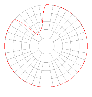
Directional Antenna
Antenna Make/Model: Propagation System Inc FMC-1-DA
Antenna ID: 129417
Polarization: H
| Primary Station |
| WZXX(FM) |
Ch. 203 | Lawrenceburg, Tennessee |
|
Structure Information
Structure Registration Number 1206253
Structure Type: GTOWER
Registered To:
American Towers LLC
Structure Address:
315 Chester Avenue (#23656)
Atlanta, GA
County Name: Fulton County
ASR Issued: 09/10/2025
Date Built: 05/14/2002
Site Elevation: 295.4 m (969 ft.)
Structure Height: 291.4 m (956 ft.)
Height Overall: 329.2 m (1080 ft.)
Overall Height AMSL: 624.6 m (2049 ft.)
FAA Determination: 09/09/2025
FAA Study #: 2025-ASO-13697-OE
FAA Circular #: 70/7460-1M
Paint & Light FAA Chapters: 4, 9, 15
PRIOR STUDY 1999-ASO-3660-OE
33-44-40.9 N 84-21-35.7 W (NAD 83)
33-44-40.5 N 84-21-36.0 W
(Converted to NAD 27)
|
W209CD(FX) Licensee Information
Radio by Grace, Inc.
160 Gooding Street West
Twin Falls, ID 83301
Phone: 208-733-3551
Not-for-Profit | 0000118010 Applicant Information
William Gehm
Title: President
Date: 07/17/2020
Application Certifier
Radio by Grace, Inc.
Radio by Grace, Inc.
160 Gooding Street West
Twin Falls, ID 83301
Applicant
Jim Turvaville
Turbo Tech Services
360 Patton Street - PO Box 144
Mobeetie, TX 79061
Consulting Engineer
|