|
Channel: 211B 90.1 MHz
Allen Park, Michigan
Service: FM - A full-service FM station or application.
Facility ID: 768011
FRN: 0017040510
Fac. Service: FM
Status: CP
Application Accepted: 01/07/2022
Application Granted: 02/29/2024
File Number: 0000167787
CP Expires: 02/28/2027
Application Type: Non-Commercial Educational Amendment
FCC Website Links:
LMS Facility Details
This Application
Other Applications
Including Superseded Applications
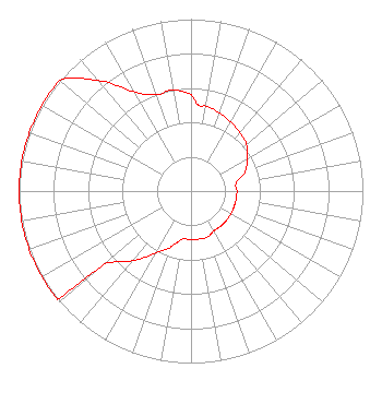
Service Contour - Open Street Map or USGS Map (60 dBu)
Service Contour - KML / Google Earth (60 dBu)
Facility Type: NON-COMMERCIAL EDUC. FM
Class: B, A Zone I or I-A station; with 25kW-50kW ERP and a class contour distance 39km-52km
Site Location: 42-10-08.0 N 83-12-49.0 W (NAD 83)
Site Location: 42-10-07.9 N 83-12-49.3 W (Converted to NAD 27)
Effective Radiated Power: 50 kW
Antenna Center HAAT: 95 m (312 ft.)
Antenna Center AMSL: 271 m (889 ft.)
Antenna Center HAG: 89 m (292 ft.)
Site Elevation: 181.7 m. (596 ft.)
Height Overall*: 96.3 m (316 ft.)
(* As Filed In This Application, may differ from ASR Data, Below.)
Directional Antenna
Antenna Make/Model: None
Antenna ID: 0
Polarization: H
| Associated Translators |
| XHTFFM |
Ch. 0 | Monclova, Coahuila |
|
Structure Information
Structure Registration Number 1006095
Structure Type: TOWER
Registered To:
VB Nimbus, LLC
Structure Address:
Sw Cor Sibley Rd & Grange Rd
Riverview, MI
County Name: Wayne County
ASR Issued: 10/15/2020
Date Built: 01/01/1985
Site Elevation: 181.7 m (596 ft.)
Structure Height: 95.4 m (313 ft.)
Height Overall: 96.3 m (316 ft.)
Overall Height AMSL: 278 m (912 ft.)
FAA Determination: 10/11/1996
FAA Study #: 96-AGL-3232-OE
FAA Circular #: 70/7460-1J
Paint & Light FAA Chapters: 3, 4, 5, 13
42-10-08.0 N 83-12-49.0 W (NAD 83)
42-10-07.9 N 83-12-49.3 W
(Converted to NAD 27)
|
NEW Licensee Information
Smile FM
172 N Cedar St
Imlay City, MI 48444
Phone: 181-089-5204
Not-for-Profit | 0000167787 Applicant Information
Edward Czelada
Title: President
Date: 01/07/2022
Application Certifier
Smile FM
172 N Cedar St
Imlay City, MI 48444
Applicant
Edward Czelada
Smile FM
172 N Cedar St
Imlay City, MI 48444
|